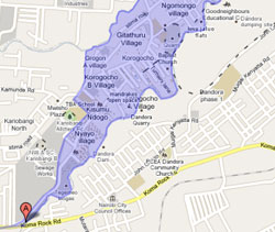
(November 29, 2010) The slum of Korogocho in Nairobi, Kenya is one of the largest by population in Africa. Some 200,000 people live shoulder to shoulder within the shanty town of tarps and metal sheets in an area no bigger than a few New York City blocks. But Korogocho now has a more important distinction. For the first time, Korogocho is now on the map – literally. Thanks to a partnership with Google, the nonprofit media development organization Internews has made the first ever map of Korogocho. In addition to helping improve the speed and accuracy of health information, the new project is giving people a sense of community like never before. Knowing where you are on a map, it turns out, has an ability to bring people together, even in the most difficult of living conditions. "The enthusiasm, passion and pride that the residents of Korogocho have over this project is amazing,” said Deborah Ensor, regional director for Internews projects in Africa. “To know that your community is part of a pilot that could revolutionize the way health care is delivered, to know that you are inventing a system with new technology and tools that can improve and even save lives, well, it is an awesome thing to be a part of for all of us.” To a community whose home is known as an ‘informal settlement’ or ‘slum,’ creating what would become the official record of their home on Google Maps may have seemed at first unlikely, simply because this neighborhood is so often forgotten. But it was with great enthusiasm that Korogocho residents began plotting out the landmarks of the settlement using Google satellite imagery. The map, which was started on Nov. 15, will help monitor and visualize timely health information in the Korogocho community. The project was carried out by a group of Korogocho residents, journalists from a local community radio station, and health workers who mapped out the nine villages within Korogocho in immense detail. Google Kenya was impressed with the detailed work the group managed to do in just three days. Jacqueline Rujuai, a Google mapping expert, said she was “blown away by the passion” the group had shown in mapping their neighborhood. The project will help ensure that health information trends can be quickly identified and located, then interpreted and broadcast on Koch FM, the community radio station in Korogocho whose journalists helped with the mapping. Ultimately, the project seeks to create an information chain from community health workers to the radio station to listeners, using SMS texting and new media platforms. Njeru Munyi of Koch FM, said that besides the excitement of putting his radio station on the map, he is now able to clearly visualize the area where his station reports from and broadcasts. He said this will help him network with community health workers and residents who will contribute in gathering information for the station. Health workers, meanwhile, say it will make the coordination of their work much easier. “I have already begun pointing out to the volunteers who come to work with us, even from outside Kenya, the exact spots where we work,” said Aggrey Avendi, a community health worker said as the mapping was being completed. “Now we are just waiting for the project to kick in and it will all come together.” |
-
Health Summaries
Maternal health goal still a farfetched dream New treatment methods lower TB infection rates Kenya: NCDs and HIV fight for limited resources Tuberculosis and HIV rife in Kenya prisons HIV screening, ignorance keeping blood donors away New strategy now planned to increase HIV testing Maternal, child health highway littered with broken promises Concern over HIV in schools rises View all -
Democracy and governance Summaries
NGO Wants Seat in Land Committee Did Hague Hearings Shake us out of our Rigidities? Mutula Tells CIC to Stop Opposing Change of Election Date Mutula Faults ICC over Failure to Record Big Three TJRC Promoses Justice for Kiambaa Fire Victims Ghaii Says Polls should Held in Early 2013 Listing of Wealth will Curb Graft, Panel Told Telkom Kenya Sued in Sh1.5bn Land Sale Row View all Twitter
 Mtandao Wa InternewsA platform for Kenyan journalists to share stories
 Work with us Opportunities to join the great team!
 Internews E-Learning. Online platform for trainer trainee interaction
 OpportunitiesCurrent and upcoming opportunities for journalists